
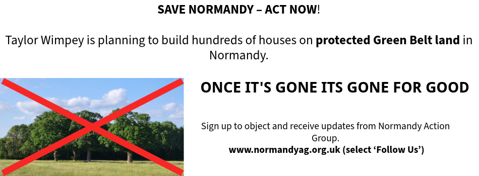
Our Normandy Village - Once its gone, its gone for good

Our Normandy Village - land near Pusseys Copse with Ancient Woodland

Our Normandy Village - view to the Surrey Hills National Landscape

Our Normandy Village - St Marks Church, Wyke, 15th c.


Follow us on
![]()
![]()
![]()
![]()
Planning Matters #12 of 2025
30 September 2025
In this edition:
- TW shows (some of) its hand with EIA Scoping Request
- No change so far on Local Plan timetable
- Traffic Monitoring Mystery?
- Last chance to complete survey
TW shows (some of) its hand with EIA Scoping Request
Ahead of an outline planning application for its proposed major development in Normandy, Taylor Wimpey has submitted to Guildford Borough Council (GBC) what is known as an Environmental Impact Assessment (EIA) Scoping Request. This seeks to ascertain which issues need to be included in the EIA, which will form part of the planning application.
The (154 page) document has just appeared on the GBC planning website, and you can view it by clicking on the button below. You can get a flavour by reading the first three chapters (15 pages), including (para 3.1.2) an outline of the “anticipated” major elements of the scheme. It includes fresh details, which in some cases are quite alarming. These include:
- The application will be for “up to 950 dwellings (including 50% affordable)” (para 3.1.2)
-“The majority of the proposed development will be under five storeys in height, with the majority of the dwellings likely to be between two and three storeys.” (para 5.1.25)
- Construction activity will take place over at least a ten year period up to 2037 (para 16.2.21)
The document is essentially about methodology, but seems to us that some of the claims made by TW’s agents, Savills, regarding areas that they argue should be ‘out of scope’ should be contested.
For example, the document argues (para 5.1.28) that “given the urban-fringe character of the Site (located close to Normandy and Flexford) it is considered that it is not sensitive to minor increases in sky glow which might be expected from the introduction of the proposed residential-led development.” We find the characterisation of 148 acres of previously undeveloped land as “urban fringe” pretty astonishing, and the suggestion that the additional sky glow from “up to 950 dwellings” does not merit an environmental assessment a bit rich.
Equally (Table 12.6), the area of “community identity, culture, resilience, and influence” is "scoped out” on the basis that “stakeholder engagement with the existing community will be important to inform the design of the proposed development, and will be managed through the central EIA process, to ensure the proposed development contributes to the needs of the existing neighbouring community and addresses any concerns.” Again, the idea that such a development - which would pretty much double the size of Normandy, and would remove at a stroke its green core - does not need to be addressed in the context of its impact on community identity and culture, is at best naive and at worst disingenuous.
No change so far on Local Plan timetable
We have reported previously on GBC’s timetable for updating the Local Plan, against the possibility that it might be accelerated. GBC has told us that it remains as published in February 2025, although it is still waiting for the promised updated guidance on Local Plan setting and updates from the Government. The latter was expected in Summer 2025 but the timescale appears to have slipped again.
We have also asked GBC for an update on the updated Green Belt Study that will inform the Local Plan. We have been told that a contract has been signed and that GBC hopes to be able to show the outcomes of this and the other assessments it has commissioned in late Spring/early Summer of 2026.
Traffic monitoring mystery?
There has been much speculation about the provenance and the purpose of the double rubber tubes that have been laid across the highway both within Normandy and in the surrounding area, for traffic monitoring purposes. Our County Councillor, Keith Witham, has managed to ascertain that not even Surrey Highways know who is responsible for installing these, and that - astonishingly - companies undertaking such surveys do not always notify Highways in advance or seek permission. Highways are trying to find out more.
It is worth noting, in the light of some of the speculation and comments on social media about this, that the geographical scope of any TW traffic monitoring in connection with their application “will extend from the A331 in the west to Guildford in the east. It will also extend from A324 Pirbright Road in the north to the A3 junction with the B3000 Puttenham Heath Road in the south.” (para 16.2.20 of the EIA Scoping Request)
Last chance to complete survey
Throughout September we have been running a pulse survey of our followers to gauge the strength of opinion about the possibility of hundreds of new homes being built in Normandy. (NB this is not a substitute for the household survey that will be conducted by the Parish Council in November once further details of the TW proposal are known.) We will publish the results shortly, but will give anyone who has not yet responded until close of play on Friday, 3 October to do so before we close it.