Dear NAG Follower,


A very full newsletter this edition with a large number of planning applications locally and further afield that directly and indirectly affect Normandy.


In this edition:


  • New National Planning Framework
  • Report from our Annual General Meeting
  • Challenges of Enforcement
  • 'Limited Infilling’ in Normandy
  • Other local cases
  • Applications from further afield


New National Planning Framework


The long-awaited revision to the National Planning Policy Framework (NPPF) was published on 19 December. Housing targets are now advisory rather than mandatory, although Government has elsewhere given itself greater powers to overrule Local Plans. There is no longer a requirement for Green Belt boundaries to be reviewed or changed when Local Plans are being prepared or updated.


Report from our Annual General Meeting


The draft Minutes of our meeting on 31 October are on our website here. We were pleased to be joined by three Guildford Borough Council (GBC) Councillors, and much of the discussion was about the constraints under which the Council was operating, especially regarding enforcement. We did suggest they could do better at keeping the public informed, though, to maintain some faith in the system. For more details, please see the draft Minutes.


Challenges of Enforcement


The most recent visible evidence of the enforcement challenge is the unauthorised development of the plot to the south of the A323 between Wyke and Ash – see previous newsletter. The situation now is that GBC will (belatedly) decide on the original planning application 21/P/02167. If it is approved, no further action will be taken. If it is rejected, the applicant has the right to appeal, and only if the appeal is rejected can enforcement action begin. This whole process takes a great deal of time, so do not expect to see any action on that site in the foreseeable future. The original application attracted only two public objections; as we say in our regular articles in The Villager: “Join our free mailing list and become better informed about local issues. Don’t wait until something you don’t like starts happening on your doorstep!”


The delays inherent in the system, which always favour those who choose to ignore or push the boundaries of the rules, are also evident in the continuing eyesore at Wanborough Fields. There are 11 open enforcement cases there, going as far back as 2018, with at least one new one every year. We reported in our last newsletter that one of these, relating to the unsuccessful application 18/P/00044 for conversion to equestrian use, was about to go back to court, but frustratingly the hearing has been postponed to May 2024. Meanwhile the subsequent owners of the same plot have now taken to appeal the refusal of their application 22/P/01326 for an agricultural storage barn and chicken house…


'Limited Infilling’ in Normandy


We reported in our last newsletter on the application 23/P/00361 for the construction of two detached houses and garages at Wyke Lodge (opposite St Mark’s Church), and said this would be a further test of how the concept of ‘limited infilling’ in areas of Green Belt that fall outside the official settlement area is interpreted. That application has now been approved, as has 22/P/00174 for 5 detached houses at the rear of Vaglefield Farm in Glaziers Lane. Both these decisions have been justified as ‘limited infilling’ in areas that although outside the settlement area are deemed to be part of the village of Normandy. Because this policy of ‘limited infilling’ could have an important impact on how Normandy looks in future, we have summarised some of the issues and relevant cases in an article on our website.


Other local cases


We reported in our last newsletter on application 23/P/01507 for a care home to the south of North Wyke Farm with 17 one bedroom bungalows with staff accommodation and 10 one and two bedroom affordable homes. This attracted 7 objections from members of the public and Normandy Parish Council; it has now been withdrawn.


Application 23/P/01744 is for the proposed conversion of the existing stables and storage barn into a single residential unit at Fairoaks Smallholding, Aldershot Road. This site is in the Green Belt, but surprisingly, there is no reference to this in the ‘Design and Access Statement’.


A similar case 23/P/01436 at Woodlands Stables, Green Lane West, Ash (but falling in Normandy and Pirbright Ward), also in the Green Belt, is for a change of use of land to a travellers caravan site. This has already attracted 15 objections from members of the public. Both of these proposals would appear to fall outside national and local rules for development in the Green Belt.


A reminder that NAG does not try to comment on all planning applications in Normandy, only those that raise wider policy issues. All applications in Normandy go to public meetings of the Planning Committee of Normandy Parish Council; conclusions are on their website.


Applications from further afield


Here we mention:


23/P/01831 for a McDonald’s Restaurant at Tongham service station, adjacent to the nature reserve at Tice’s Meadow (105 objections, plus a Petition),


23/P/01850 for a major residential care development at The University Of Law, Portsmouth Road (64 objections)


23/00794/REVPP for the Farnborough Airport proposals (2406 comments – presumably mainly objections!).


22/P/02178 for a solar facility proposed to the west of Blackwell Farm (64 objections). There is still no decision on this application.


Since this article was published we have provided a comment for an article on the same subject in the Guildford Dragon, here. Now read on!

In recent months local residents have watched with dismay as the once pristine field in the Area of Great Landscape Value to the right of Westwood Lane as it bends left at Wanborough Fields has seen extensive offloading of ballast, the erection of fencing, and the open storage of building materials, including containers. Aerial photos showing just some of the damage done can be seen here. Following determined lobbying by residents and local Councillors alike Guildford Borough Council (GBC) has finally issued an Enforcement Notice and a Stop Notice on the owners of the plot in question and their agents.


The deadline for responses to the Government’s consultation on changes to the national planning system is fast approaching; we have until 29 October to make our comments.The Government is proposing changes to the system that some believe could pose a huge risk to the countryside and the communities living and working within it.

It seems Guildford borough is the big loser, accounting for 46% of the annual loss of Green Belt, reducing the area of Green Belt in the borough by 6%. Local residents' groups opposed to this significant loss went to the extent of forcing a Judicial Review of the Guildford Local Plan process carried out by Guildford Borough Council under its previous leadership but to no avail.

Because of the current public health restrictions this year's Annual General Meeting will be held online via Zoom. It will be on Tuesday, 3 November 2020 at 2000 hrs. We hope to see a good number of you there to receive our report on the past year and our thoughts about the year ahead.

Many local residents understand the frustrations of travelling out of Normandy towards Aldershot or the A331 when confronted with closed gates at Ash Station.  There are many arguments for and against the creation of a bridge to obviate the tailbacks. One thing for sure is that it will affect the flow of traffic along the A323 through Normandy.

A planning application [19/P/01460] is to be considered by Guildford Borough Council Planning Committee later in the year.

This article, written by NAG chairman Mike Aaronson, was first published in the Guildford Dragon on 15 September 2020.

The recent White Paper on reforming the planning system, although a mixed blessing, includes a welcome emphasis on “protection” for green belt and other sensitive landscapes.

But it fails to address planning enforcement. There is no point in having a planning system if it can be flouted with impunity. Would-be developers need to understand that if they break the rules they will be penalised, and swiftly.

There is still no news about the public consultation regarding the Ash Ranges. In January 2020, the MoD published a “Communications Plan for the Proposed New Aldershot & District Military Lands Byelaws”, which stated that public consultation would start in April. A subsequent update said that this had been delayed, although both documents now appear to have disappeared from the web. In the meantime there is a Petition calling for there to be no reduction in public access to the ranges, which has already attracted nearly 11,500 signatures.

The close date for the ongoing consultation on the “Guildford Local Plan: Development Management Policies - Issues and Preferred Options” approaches. Details of the consultation documents and process for commenting are available on the GBC website. The Council states that this process:

“Will provide further and more detailed planning policies to use when we determine planning applications. This Regulation 18 consultation is the first opportunity to comment on the plan as it moves through the various stages of its production."

The most recent success enjoyed by local residents has been the refusal by GBC’s Planning Committee on 17 June 2020 of the application 19/P/01980 for a horticultural business in the smaller field just to the right of the road before the bend. This went to the Committee in February because over 20 objections were received (in fact 26, all strongly objecting).

The land at Wanborough Fields is the large open field running down from the Hog’s Back to Westwood Lane and the smaller field to the right just before the first sharp bend to the left coming from Normandy. The upper half of this land is in the Surrey Hills Area of Outstanding Natural Beauty (AONB) and the lower half is designated an Area of Great Landscape Value (AGLV). As long ago as 2013 it was recommended that the AONB boundary be changed to include the AGLV. This has dragged on and on, but earlier this year we were promised that Natural England, who would be responsible for any review, were shortly to start on it.

GBC has started work on the second part of the Local Plan; the ‘Local Plan: Development Management Policies’ document. The Council states that this “will provide further and more detailed planning policies to use when we determine planning applications. This Regulation 18 consultation is the first opportunity to comment on the plan as it moves through the various stages of its production. The document identifies a series of key issues for the borough and the policy options that could help address them.

At the national level, government has made clear its intention to reform and simplify the planning system. No doubt every government has this aspiration but we should take it seriously and watch closely for changes that might have a negative impact on semi-rural areas such as ours.

Less positively, the smaller field of Wanborough Fields to the right before the bend in Westwood Lane continues to be blighted by the various structures that were erected not long after the plots were sold and whose owners have been directed to take them down.

Notwithstanding the failure of the various attempts to have the Local Plan subjected to Judicial Review, the Save the Hog’s Back Group has written to all Councillors asking them to review the Plan in the light of the absence of any proposals for A3 widening in the Government’s Road Investment Strategy, which was published in March.

Planning application 19/P/00167, which was an outline application to consider access for change of use and creation of up to a total of eleven dwelling houses at Wanborough Business Centre, having been refused by GBC, subsequently went to Appeal [APP/Y3615/W/19/3240419]. The Planning Inspectorate dismissed the Appeal on the grounds that would be “inappropriate development in the Green Belt”.


GBC has refused an application [20/P/00113] for a Certificate of Lawfulness for the sinking of a borehole by the owner of one of the plots in the AGLV part of the larger field at Wanborough Fields.

Such a Certificate would have meant the applicant did not need to apply for planning permission. We now wait to see whether planning permission is sought. 

Following the rejection by the judge of the three requests for Judicial Review against the Guildford Local Plan, two of the three claimants (Compton Parish Council and Jules Cranwell) have decided not to take matters any further, while the third (Ockham Parish Council) decided to mount an Appeal but found their case rejected.

NAG has asked GBC whether further guidance will be forthcoming on the design policies to be applied in settlements that are ‘inset’, as we believe it would be helpful for local residents to have clear guidance as to what is and what is not likely to be acceptable.

GBC refused the retrospective planning application 19/P/02128 to fence the plot on the AONB section of Wanborough Fields, so presumably in the absence of an Appeal it now needs to come down. Thirty-two residents made comments, all strongly objecting to it.

This is not strictly speaking a planning matter, but as it is relevant to local quality of life we thought it worth drawing to your attention. It concerns a research proposal from the University of Surrey that intends to undertake a study into the effects of different vegetation and leaf types on roadside air pollutant removal.

Because the Local Plan removes the settlements of Normandy, Flexford, and Walden Cottages from the Green Belt (they are now ‘inset’ rather than ‘washed over’) we can expect to see more proposals for ‘limited infilling’ within the settlement area.

Once a Local Plan is agreed the planning authority needs to consult on certain aspects of its implementation. Guildford Borough Council (GBC) is now consulting on its Draft Strategic Development Framework document which, when finalised, will provide detailed formal guidance to assist future master planning, planning and development of the strategic sites in the Local Plan, including Blackwell Farm. There is therefore an opportunity now to feed in any views on the form this development should take.

If any resident would like to comment on the draft SPD, please visit the consultation homepage. The deadline for consultation is 24 February at 1200.


Planning application 19/P/00167, which was an outline application to consider access for change of use and creation of up to a total of eleven dwelling houses at Wanborough Business Centre. This was refused by GBC,

Option M & Q Corridor 

The Option M/Q corridor in our area (Ash Green, Normandy/Flexford, Wanborough, Wood Street) has the potential for major impact on the landscape.  As the pipeline is unlikely to be routed directly through the settlement of Fexford and the hamlet of Wanborough, route options are forced to the northern and southern boundaries of the corridor proposed as Option M/Q. 

The southern boundary of the Option M corridor as it passes north of the A31 intrudes first in to the northern boundary of Surrey Hills AONB and as it passes west into the vicinity of Wanborough strikes directly through the AGLV land on the north slopes of the Hogs Back.  Any haul road and trenching work will present a significant scar in this area of striking visual amenity.

Click to watch a time lapse video of the the laying of a section of the NTS South Wales pipeline.


Impact of Civil Engineering Works

NAG are sceptical of the proposition that the potential haul, trenching and back-fill roads will be only 25 metres wide. A cursory search for images on the Internet for laying of a 30cm steel pipeline for refined product transmission, shows a range of activity and scale of civil engineering equipment to be significant.

Click to read the stages in a typical pipe laying project.

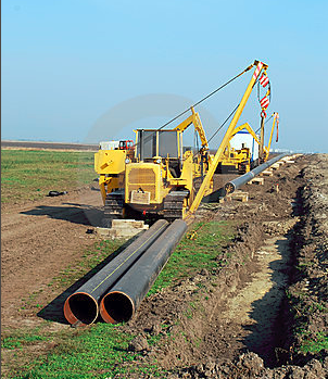
No evidence was on show at the public exhibition to illustrate the potential physical scale of operations e.g. a pipe-laying machine. No information was visible to illustrate where and how access points would be created for the delivery of hundreds of metres of heavy duty 30cm steel piping and where and how it would be stored.


Important Landscape Designation Unconsidered

The on-line map fails to take account of land classifications Area of Great Landscape Value [AGLV] and Site of Nature Conservation Interest [SNCI].  AGLV boundary maps are available from the Surrey County Council on-line interactive map service

This landscape designation is recognised by the Joint Nature Conservation Committee [JNCC] that advises government but is not taken account of by the provided public mapping solution and in that way is seriously deficient as it fails to properly inform residents of the potential impact of the pipeline laying on a well-recognised landscape classification. This is a striking landscape for which reason it will be considered for inclusion in the Surrey Hills AONB in 2019.

This land on the north slopes of the Hogs Back designated an Area of Great Landscape Value extends from the Surrey Hills AONB boundary to the north of the A31 north to Flexford Road. Any haul road for pipeline trenching will damage the visual amenity of this land.


Local Sites Impact 

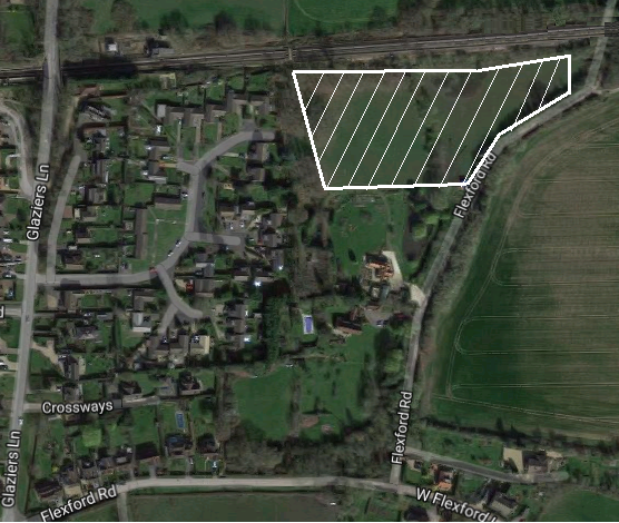
A Site of Nature Conservation Interest lies to the east of The Paddocks and west of Flexford Lane in Flexford and south of the North Downs Line. The geographic reference for this site can be seen on page 306 of the Guildford Borough Council SHLAA December 2012.  This land has subsequently been withdrawn as a potential development site from the Guildford Submission Local Plan 2018 and recently had a planning application for housing rejected by Guildford BC Planning Committee due to its SNCI status. This site lies in the potential path for the pipeline and should be avoided. 

Other land previously subject to planning applications for housing is the field/site opposite The Paddocks to the south of the North Downs Line and the east of Glaziers Lane. These limit the opportunity to route the pipeline north of the North Downs Line as the boundary crosses Glaziers Lane and would block routing to the north-east towards Bailes Lane.


Woodland Threatened

The land proposed in the Option M corridor is shown to contain a large amount of Ancient Woodland and other woodland extensions at the margins of the stands of Ancient Woodland.

Of major concern is the pinch point between the north boundary of Wanborough Wood and the south boundary of Highfield Copse, in particular Week Wood. The Option M route boundary drawn around Wanborough Wood appears to force the likelihood of part the woodland of Week Wood on its south side to be cleared to enable any haul road and trenching. This is unacceptable. 

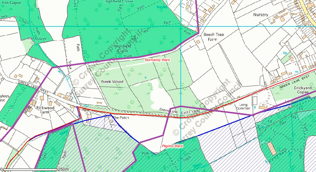
Much of the local wood stands are habitat for a local deer population and any civil engineering activity would represent a major disturbance and loss of habitat for a normally shy species. The southern boundary of Option M at this point appears to cut directly across the AGLV land that lies between Grubground Copse and Wanborough Wood leading to some woodland clearing should a path be forced here. This is unacceptable.

Where the boundary approaches from the west and strikes north from its touch point on the ancient woodland of Highfield Copse, the boundary passes directly through properties to the end of Beech Lane at Beech Tree Farm. It is totally unacceptable to propose laying through private gardens. To route outside the boundary to the west of Beech Lane would damage the ancient woodland of Highfield Copse and this is also unacceptable.


Public Rights of Way

Any routing in this corridor as a whole will severely disrupt a series of well-established and used Public Rights of Way as established and maintained by the Countryside and Rights of Way Act 2000.

The following footpaths and byeways are at risk: FP358 , BY522, BY524, BY523, FP375, FP376, FP453, FP381, FP380, FP374, BW381, BY534, FP377, FP385. These form one of the densest networks in the west of Guildford borough. This is unacceptable.

In addition there is the potential for Byway 523 and 524 to be disrupted. This is unacceptable.

Byeway 524 that runs along Beech Lane is subject to significant flooding despite the Normandy Flood Forum working with National Rail and Thames Water to alleviate the problem as the water table is blocked by the railway embankment of the North Downs Line as it runs to the south of Beech Lane. Any subterranean works such as pipeline laying has the potential to exacerbate flood risk here rather than alleviate.  This is unacceptable. 


Pressure on Road Infrastructure

NAG believes the northern boundary of Route M&Q through Normandy that runs to the north of the North Downs Line is infeasible on both sides of Glaziers Lane in the approach from the west and exit to the east. It appears the intention is to run the pipeline either under or alongside the North Downs Railway line at the Glaziers Lane bridge. The corridor formed by the boundary of Option M corridor to the north of the North Downs Line that crosses Westwood Lane is narrow and likely subject to groundwater flows, again as a result of the proximity of the North Downs Line embankment.

Any cutting of Westwood Lane even for a temporary period will disrupt the traffic flow of a Class D road that acts as a feeder from the A31 to the A323 and A324 (historic traffic counts indicate 1,000+ vehicle movement per day at peak times). This is likely unacceptable to road users and will divert excessive traffic down Glaziers Lane that has a 30 mph speed limit and at points poor sight lines that have caused a small number of serious accidents in the past. This outcome would be unacceptable to residents.

The bridge has seen a gradual deterioration of its northern and southern approach slopes with some slippage on both sides of Glaziers Lane exposing the front edge of the reinforcing concrete slab. Any further disturbance by vibration from large-scale pipe-laying activities in close proximity might lead to the closure of Glaziers Lane for bridge repairs. Although a Class D road, Glaziers Lane is used by through traffic HGVs for access to the A323 towards the Ash area to the west and to the Worplesdon area to the east. Any damage to the road bridge would be disruptive to local vehicle movements.


Other Potential Disruption

As the north boundary of Option M corridor approaches the railway bridge at Glaziers Lane that crosses north-south over the railway line, it narrows to follow the railway line creating a further pinch point in potential pipeline routing. Either the pipeline trench will have to pass under the bridge on National Rail land or through the embankment to the south of the bridge simultaneously forcing it to cross the land of 174 Glaziers Lane. This is unacceptable.

Although reinforced some 40 years ago, the bridge has suffered front and rear edge subsidence as a consequence of local HGV traffic. Any vibration or disturbance caused by pipeline trenching and laying may well exacerbate this subsidence and further damage the bridge in such a way to disrupt through traffic feeding the A323 and A324.

Due to the restrictive bridge in Westwood Lane under the North Downs Line, HGV traffic chooses to use Glaziers Lane that suffers a disproportionate volume of such vehicles when added to those servicing local businesses. Any civil engineering operations (e.g. extended road closures) that disrupt this traffic flow will have a back up effect onto the A31 at peak times.

A Waste Cardboard and Waste Paper recovery and transfer facility [SCC 2017/0118 and GBC 17/P/01585has been approved on part of the Earth Station site in Cobbett Hill Road, Normandy for the sorting and storage of cardboard and paper but not the actual recycling, which is done elsewhere.

Following the public consultation at Normandy Village Hall, a new application for 30 new dwellings at Elm Gardens Centre in Glaziers Lane has recently been validated by Guildford Borough Council [17/P/02326]. This site is previously developed land in the Green Belt and as such any decision is likely to involve consideration of the impact on openness of the Green Belt of the proposed development when compared to the current site use (see NPPF para 89).

In a published decision [APP/Y3615/W/17/3173871], a planning inspector dismissed the appeal against the refusal of outline planning permission for 30 dwellings at land behind 140 Glaziers Lane. The inspector highlighted the impact on openness of the Green Belt of this proposal, the development likely to be at odds with the linear development along Glaziers Lane, and the location of the site within 1 km of the Thames Basin Heaths SPA and the lack of available SANG at the time of the decision. In addition, the very special circumstances required to justify such development in the Green Belt had not been demonstrated.

To the dismay of residents in areas in the west of the borough threatened by housing developments on Green Belt land within the 5 kilometre buffer zone of the Thames Basin Heaths Special Protection Area [TBHSPA], an appeal to overturn the rejection of a planning application [13/P/01453] by Guildford Borough Council planning committee, to convert the 34.5 hectares of Russell Place Farm into Suitable Alternative Natural Greenspace [SANG], was upheld by the planning inspector.

Normandy Parish Council has objected to proposals for six 2-bedroom dwellings located near the junction of Wyke Lane and the Guildford Road. The site is located within the Green Belt, beyond the settlement boundary and within the 400 metre exclusion zone of the Thames Basin Heaths Special Protection Area.

Planning application 17/P/01451 has attracted significant opposition among residents. Over 70 letters of objection have been submitted and a residents association formed to combat the proposal.

The planning application is for 25 dwellings and their associated infrastructure needs and accommodation for over 50 vehicles. The land was previously included in the Regulation 18 version of the Guildford Local Plan draft but withdrawn from the Regulation 19 draft.

The application [SCC 2017/0118 and GBC 17/P/01585] for the change of use to waste paper and waste cardboard recovery and transfer facility, plus overnight HGV parking at Cobbett Hill Earth Station, Cobbett Hill Road, Normandy, Guildford, Surrey GU3 2AA is due to be considered by the Surrey County Council Planning Committee on 15 November 2017.

More than 20 residents have submitted comments to Guildford Borough Council and some to Surrey County Council Waste & Minerals Planning team on this proposal, the majority in opposition.

Subsequent to the publication of the Housing White Paper, the government delayed the release of proposals for a 'standardised' method of calculating 'housing need' in a local plan. The proposed formula, where 'affordability' now plays a major part, is subject to consultation, with the consultation period ending in November 2017.

Local community groups have been dismayed to see that this formula, if applied to Guildford borough, would result in a 59% uplift in currently proposed housing targets contained in the draft Guildford Local Plan, according to the data table released by the government.

Guildford Borough Council report that 9,500 comments from 3,300 individuals and organisations were received in response to the the June/July 2017 consultation on the updates to the Local Plan.

Over 6,000 residents, businesses, community groups and stakeholders made 32,174 comments during last year's Regulation 19 pre-submission public consultation in June/July 2016. Those comments remain valid and will be submitted alongside the subsequent comments made about the changes to the plan during this second Regulation 19 consultation.

The council leader has stated that the council remains on target to submit the plan to the Planning Inspector in December 2017.

Residents of Glaziers Lane have recently attended an "exhibition" at Normandy Village Hall for a substantial housing development at the former Elm Gardens site. This would represent the first steps in a planning application, characterised as a 'public consultation' exercise.

Currently occupied by a number of small businesses and a large storage facility for concrete framed building components, the accompanying site layout illustration suggests approximately 30 or so dwellings, with a mixture of detached, semi-detached and terraced units of 2, 3 and 4-bedrooms.

A proposal for the demolition of Vaglefield Farm and its associated agricultural outbuildings in support of planning application 17/P/01840 for four detached and two semi-detached dwellings has been submitted. When combined with the application for nine detached dwellings at land adjacent to the North Downs railway line [17/P/01413], Glaziers Lane is now subject of two applications and one appeal for new housing.

A number of years have elapsed since the failed application for an old people's home on the former Duke of Normandy public house site was rejected by council planners, to be followed by a similarly rejected proposal for four dwellings. The new application [17/P/01784] is for three three-bedroom dwellings fronting Aldershot Road.

The land adjacent to the North Downs railway line, north of the railway bridge and east of Glaziers Lane, has had a new planning application submitted. Originally brought forward as a site in the 2014 draft Guildford Local Plan and subject of a more recent planning application [16/P/01452] for 42 dwellings, the new proposal [17/P/01413] is for 9 detached and semi-detached dwellings; the submitted site plan envisages a combination of 3, 4 and 5-bedroom properties within the existing building line.

Residents at The Paddocks were shocked to receive notification from Guildford Borough Council in early July 2017 of a planning application 17/P/01451 for outline permission for 25 homes on land at Little Flexford. The close date for residents' comments is 11 August 2017.

The owners of land at 140 Glaziers Lane have initiated an appeal against the refusal of the application for outline permission for the erection of 30 new houses. Residents that previously commented received a letter from Guildford Borough Council [GBC] dated 11 July 2017 informing them of the appeal. The close date for residents' comments is 8 August 2017. The PINS appeal reference is APP/Y3615/W/17/3173871, GBC reference 16/P/00649. The appeal will be determined on the basis of written representations.

Outline permission is being sought for 300 homes on the far western border of Normandy ward [17/P/00507], 500 metres from the north part of Site A29 opposite Ash Hill mini-roundabout on the A323 at the eastern border of Ash South & Tongham ward (a total of 1,750 homes) proposed in the draft Guildford Local Plan 2017.

House builder Bewley Homes has submitted a planning application [17/P/00513] on land at Ash Manor, SAsh Green Lane for 95 homes. This appears to be part of a two phase approach where, if Phase 1 permission is granted, a second phase application for a further 97 homes will follow. 

Normandy Action Group is pleased that the council has responded to residents' concerns that the evidence brought forward to justify 1,100 homes on Site A46 was incorrect, removing the site from the Local Plan; Site A47 (an SNCI) has gone too.

Planning application 16/P/01452 for 42 dwellings on land east of Glaziers Lane, adjacent to the North Downs railway line and north of the railway bridge, has been refused. While there were circumstances that weighed in favour of the development, according to the decision letter, they did not amount to the "very special circumstances" needed to outweigh substantial harm to the Green Belt.

The second planning application [16/P/02134] for change of use from agricultural land to Suitable Alternative Natural Greenspace [SANG] at Russell Place Farm, Frog Grove Lane, Wood Street has been refused by Guildford BC Planning Committee, overturning the recommendation of the case officer.

This outline application [16/P/00649], for a development of 30 homes (including 11 'affordable units'), was refused by Guildford Borough Council on 15 December 2016, having received over thirty objections. The revised documentation submitted by the applicant in October 2016 did not appear, on balance, to impact the extensive case officer reportHowever, all the way through the officer report there was constant reference to the emerging Local Plan indicating this land might be part of a larger development (i.e. Site A46) still under consultation.

Residents have been surprised to learn that the property previously known as "Chyfields" at the far end of Flexford Road on the north side of the North Downs railway line towards Guildford has had its name changed to "Chimney Farm" and has new occupiers who have submitted a planning application [16/P/02246] for a change of use for the extensive property. 

Guildford Borough Council [GBC] Planning Committee recently refused an application at Long Reach, East Horsley [16/P/01459] (similar to that at Russell Place Farm, Wood Street), for the creation of a "nature reserve" to "facilitate a SANG" (Suitable Alternative Natural Greenspace)

A busy back route for HGVs, from A31 Hogs Back to the A323 Aldershot Road via Flexford Road and Glaziers Lane, avoiding the restricted-height bridge in Westwood Lane, will have street lights switched off 12.00 midnight - 5.00 a.m.; Westwood Lane remains unaffected. Most of Flexford will go dark.

Last month, members of the county council’s cabinet approved the proposal to switch off 44,000 street lights in residential areas of Surrey between midnight and 5am, helping the council save £210,000 per year of the £3m annual cost (7%). The first phase of the controversial project is set to begin December 2016.

This ‘private’ SANG proposal [16/P/02134], reclassified as a “nature reserve” by GBC officers, is pivotal in GBC’s draft Local Plan to offset loss of Green Belt land for 1,300 new homes [Draft Local Plan - Infrastructure Delivery Plan] in the 400m-5km mitigation zone of Thames Basin Heaths SPA. As a large site of 34.5 ha, its sphere of influence is up to 5km, covering in particular 900 proposed new dwellings in the Tongham/Ash Green area.

The two most senior officers at Guildford Borough Council are to leave their posts; the Managing Director, Sue Sturgeon is to retire in May 2017 and Deputy Managing Director, Satish Mistry to spend more time with his family at his London home. As yet there is no indication as to their replacements.

At an EGM of the full council on 27 Oct 2017, it was announced that a further restricted Regulation 19 consultation on the proposed Guildford Local Plan will take place in 2017, delaying the plan process by a further 10 months.

In an article in the Sunday Times newspaper, 23 October 2016, it is revealed that "about 32,000 comments" were received in reply to the July 2016 draft Guildford Local Plan Regulation 19 consultation; this is a substantial increase over the reported 20,000+ received in reply to the July 2014 Regulation 18 consultation. This volume is among the highest in the country in response to a local plan consultation.

Surrey County Council [SCC] are considering a new planning application [SCC 2016/0149; GBC 16/S/00009] from TGM Environmental for a waste licence to use 0.53 hectares of land at Cobbett Hill Business Park (formerly the Earth Station site) for the processing of waste paper. SCC have assessed the need for an Environmental Impact Assessment [EIA] and have found it unnecessary.

Borough-wide referendum 13 October 2016

Guildford's political groups have united to campaign against introducing an elected mayor system in an up-coming referendum that could change how the borough is governed. 

The referendum is being forced by a petition launched by former councillor Monika Juneja asking whether Guildford borough should be led by an elected mayor; campaign flyers are already beginning to be distributed in the borough.

Normandy residents attended the public enquiry at GBC Millmead, Tuesday 2 August 2016, along with Normandy's Guildford Borough Councillor, David Bilbe, into the appeal for 78 houses and retail space at North Wyke Farm [APP/Y3615/W/16/3146286]. NPPF paragraphs 79 and 87 held sway [see decision], the applicant providing insufficient evidence that the benefits of the development would prove the "very special circumstances" required for such a development in the Green Belt at this location.

Due to the hard work of Worplesdon councillors and all 345 residents across Wood Street, Normandy and Flexford who wrote to object, the planning application to turn 34 hectares of agricultural land at Russell Place Farm, Frog Grove Lane, Wood Street into Suitable Alternative Natural Greenspace [SANG] was refused in the vote during the GBC Planning Committee meeting on 20 July 2016. It is likely the applicant will appeal.

While residents were focussing on their replies to the Guildford Local Plan, the architect retained by the owner of land opposite The Paddocks on the east side of Glaziers Lane and to the north of the North Downs railway line was submitting a planning application [16/P/01452]. The application is proposing 42 dwellings on land that currently falls outside the settlement boundary of Flexford and is "washed over" by the Green Belt.

Normandy and Flexford residents joined the last minute rush to submit their comments before the consultation period ended at 11.59 pm., Monday 18 July 2016. Normandy Action Group submitted its  22 page critique along with an 8 page addendum that challenged the Habitats Regulations Assessment that covers the Thames Basin Heaths Special Protection Area [TBHSPA].

In surveying the attendance at the Normandy Parish Council public meeting to consider the impact of the draft Local Plan proposal to build 1,150 homes across two sites, Normandy's borough councillor David Bilbe estimated in excess of 300 residents present, of whom approximately 50% claimed to have not attended the previous meeting organised by Normandy Action Group. Perhaps the presence of Jonathan Lord MP, our local representative in Parliament was an added attraction.

The opening statement by the chair of Normandy Parish Council, Alan Cheeseman, set the scene. He was followed by Surrey County Councillor for Worplesdon division (including Pirbright, Normandy and Worplesdon) Keith Witham who succinctly summarised the three keys issues within the control of Surrey County Council [SCC] that will determine the content of residents' objections; the proposed 7FE secondary school; the impact on highways; the impact on the environment.

Following on from the community consultation earlier in the year, the full planning application for 370 homes and a 5FE secondary school was submitted to Guildford Borough Council in early June 2016.

The application has had the period for public responses extended until September 2016 to accommodate the summer holiday period. The details are as follows:

Guildford Borough Council have activated the Regulation 19 public consultation period for the draft Guildford Local Plan (12 noon, 6 June 2016) to last for 6 weeks. Borough residents are being encouraged to submit their views on the plan and its supporting evidence by 11.59pm on Monday 17 July. For Flexford and Normandy residents, this will be the third occasion they will be writing to express their opinion. 

Guildford Borough Council [GBC] has notified residents that commented on the planning application 15/P/01670 for 78 homes and retail space at North Wyke Farm, setting a date of Tuesday 2 August at 10.00 am for the planning appeal to be heard in front of an inspector at the GBC offices. The Hearing will be held in public and residents can attend. Should residents wish to speak, they must apply to the Planning Inspectorate, quoting the appeal reference APP/W/Y3615/W/16/3146286 [for contact details see previous news item]

At a well-attended public meeting and in an outburst of unity, Normandy borough and county councillors and nearly 300 residents shared the opinion that the developer-led proposal for 1,100 new homes between Flexford and Normandy in the Green Belt would be fought.

A lengthy exchange of views highlighted the issue of the proposal to build a 1,500 place secondary school and its apparent role in setting the 'exceptional circumstances' that would permit the redrawing of the Green Belt boundary around 67 hectares of land between the two settlements to support mass house building.

As a consequence of the identification of Normandy as a 'strategic site' in the revised draft Guildford Local Plan, proposed for 1,100 new homes, a school and retail developments and more, Normandy Action group is arranging a public meeting to be held in Normandy Village Hall at 7.30pm on Tuesday 3 May 2016.

Residents that wrote to object to the second planning application [15/P/01670] have been notified recently by letter from Guildford Borough Council dated 14 April 2016 that an appeal [PINS Ref: APP/W/Y3615/W/16/3146286] has been lodged against Guildford Borough Council's refusal of planning permission. The appeal commenced 11 April 2016 and comments should be submitted by 16 May 2016 to The Planning Inspectorate, 3/05 Wing, Temple Quay House, 2 The Square, Temple Quay, Bristol, BS16PN  or by email to the PINS case officer Paul Puddy at This email address is being protected from spambots. You need JavaScript enabled to view it.. In both instances, quote ref APP/W/Y3615/W/16/3146286 and 3 copies of any documents are requested.

5 days before the revised draft Local Plan was published on 4 April 2016, a new application [16/P/00649] for outline permission for 30 homes on the land to the rear of Fiddlers, 140 Glaziers Lane was submitted to Guildford Borough Council [GBC] planning department. The land lies adjacent to the public right of way that runs over the fields between Glaziers Lane and Westwood Lane.

7 April 2016

For immediate release:

Revised draft Guildford Local Plan impact on Normandy and Flexford

Chairman of Normandy Action Group, Roger Shapley commented

"Normandy Action Group is very disappointed that GBC has chosen to extract 72.4 hectares of agricultural land farmed for crops over decades and used to pasture livestock to be concreted over. While we appreciate the county council need for new school places, such provision should not be used as an excuse by Guildford Borough Council to remove this land from the Green Belt. A "developer-led" proposal means not just a school but thousands of houses for private profit. 

With the increasing urbanisation of Ash & Tongham, the Green Belt in Normandy plays a vital role in preventing urban sprawl between Guildford and Aldershot and this proposal does completely the opposite. The local infrastructure is already under strain with local flooding issues and poor sewerage services as Normandy and Flexford settlements are on the Hogs Back spring line. Doubling the size of the community will not solve these problems but likely make them worse. Developers cannot develop away the local terrain and its dominant drainage issues. 

The A323 is already at capacity at rush hour and any accident on the A31 or A3 in the Guildford stretch sees thousands of car journeys diverted down our D class roads, bringing the whole area to a standstill. 3,000 new homes implies approximately 4,750 more cars. The Surrey County Council OGSTAR traffic simulation Scenario 7 published in January 2014 shows that if all houses are built our local roads will exceed their design capacity almost continuously. Residents will be lucky to make it out of their font driveway in a car anytime. 

Our community is within the important restricted zone of the Thames Basin Heaths Special Protection Area. Introducing 1,000 school children daily and up to 3, 000 new residents with pet dogs and cats does not bode well for the rare bird species on this European protected habitat.

The community has yet to digest the full implications of this proposal and voice their response."

The revised draft Guildford Local Plan proposes 1,100 new dwellings and a 1,000-place secondary school to be built on 72.4 hectares of Green Belt land between Flexford and Normandy settlements. It is framed as a "developer-led" proposal, implying a major house builder is pressing its commercial interests on the council.

At a presentation during Normandy Parish Council monthly planning meeting 24 February 2016, residents heard from Guildford Borough Council [GBC] Lead Councillor for Planning that the 'safeguarded land' previously proposed in the draft Guildford Local Plan to be removed from the Green Belt and reserved for future housing development has had this status reversed. In addition, under the newly introduced GBC "sensitivity" analysis of land parcels, based on a traffic light system 'red', 'amber' and 'green', where 'red' is land with the highest sensitivity, this land (located in Land Parcel H12, GBCS Vol 5) has been allocated a 'red' rating. Generally, the expectation would be that this land would not be included in the draft Local Plan for any form of development and remain to fulfill its important Green Belt purpose, preventing the merging of Flexford and Normandy and restricting sprawl.

A new planning application [16/P/00222] was submitted towards the end of January 2016 for up to 254 residential dwellings on land at Manor Farm, The Street, Tongham. On approx. 13 hectares, this implies a low density development suggesting executive homes. As part of the application is a proposal for conversion of nearly 18 hectares of agricultural land to Suitable Alternative Natural Greenspace [SANG]. This land proposed for SANG is easily visible to the left of the A31 as the dual carriageway dips down from the Hogs Back towards Farnham. Both areas of land, should permission be forthcoming, would push development to within a few metres of the border of the Surrey Hills AONB.

Ahead of the scheduled parish council meeting Wednesday, 24th February 2016 at Normandy Village Hall, Normandy Parish Council has published the list of twenty-seven questions submitted by residents and parish councillors to the three portfolio holders from Guildford Borough Council who will be attending to answer the questions and make statements on their portfolios, that cover many aspects of the Local Plan.

Planning consultants acting fo the land owner say they plan to submit an application for outline planning permission for 370 dwellings and a five form entry secondary school on the land opposite Fairlands, with the housing to be three storey apartments, two and a half, and two storey houses.

As a result of government planning guidance changing, reclassifying previously developed land in the Green Belt as 'brownfield', the residents of Worplesdon find themsleves confronted by a new proposal at Merrist Wood College.  The college has published a proposal for 120 homes to be built on site to secure the financial future of the educational institution.

As one of a series of visits to all parish councils in the borough, the Guildford Borough councillors responsible for the key areas of Roads, Planning and the Environment

  • Cllr Matt Furniss, Lead Cllr for Infrastructure & Environment
  • Cllr Paul Spooner, Lead Cllr for Planning
  • Cllr Richard Billington, Lead Cllr for Rural Economy, Countryside, Parks and Leisure

are coming to make statements on their portfolios that directly impact Normandy parish and community (i.e. the draft Local Plan) at the next monthly Parish Council Meeting, Normandy Village Hall on Wednesday 24 February 2016 7.15 pm.

Residents should submit questions in writing, in advance, by the 12 February 2016 deadline as Normandy Parish Council will be forwarding the questions to GBC in order for the borough councilllors to consider their answers in advance of the meeting.The Chair of the parish council will be asking the questions on behalf of residents during the meeting.

15/P/02063 Rathfarnham House, East Flexford Lane, Wanborough, Guildford, GU3 2JP

Change of use from residential (C3) to Care Home (C2) for a temporary period of 3 years

Approved 04/01/2016

The use hereby permitted shall be discontinued on or before 01/01/2019

No objection from Surrey CC Highways Authority


Michael Cox, Renaissance Support Ltd (not listed as Director but June Conn is minority shareholder)

Julie Conn, La Vita Nova Care Home, Crann Dara, East Flexford Lane, Wanborough GU3 2JP

http://www.lavitanovacare.co.uk/

Surrey Heath BC

CASE NO: 2015/0684

LOCATION: MAGPYES BARN, HIGHAMS LANE, CHOBHAM, WOKING, GU24 8TD

PROPOSAL: Change of Use from C3 (Dwelling) to C2 Residential Institution) for 5 residents with learning and physical disabilities. (Amended plan rec'd 14/08/2015).

TYPE: Full Planning Application

APPLICANT: Mr Michael Cox, La Vita Nova

OFFICER: Mr N Praine

Registration Date 06/08/2015

Earliest Decision Date 09/09/2015

Statutory Expiry Date 01/10/2015

Surrey County Council are currently working on producing a new Rural Strategy for Surrey and would like our views.  The consultation is based on an on-line questionnaire (an empty PDF version available for download is attached to this article). Originally the deadline for completion was set to 4 January 2016 but because of the intervening Christmas and New Year period, the county council have conceded to requests from the public to extend the period to give greater opportunity to submit responses.

Ash Residents' Association [ASHRA] circulated their members on 8 January 2016, reminding them that Bewley Homes and a2dominion obtained outline planning permission to build up to 400 homes on the land known as Ash Meadows to the south of Ash Lodge Drive in the Green Belt in 2014.

ASHRA indicated that these companies will hold an exhibition at the Tongham Community Centre on Thursday 21st January 2016 from 3:30pm to 8pm. This exhibition is to display their progressed plans, prior to their submission of a detailed planning application, known as a "reserve matters" application, to Guildford Borough Council.

This of interest to Normandy and Flexford residents as the original proposals contained the designation of 24 hectares of land as Suitable Alternative Natural Greenspace [SANG] only 3.8 kilometres (approximately) from the lately refused North Wyke Farm site.

On 8 December 2015, an appeal outcome (APP/Y3615/W/15/3132375) against 15/P/00293 was published by the Planning Inspectorate that decided in favour of the appellant Taylor Wimpey for the building of 26 dwellings at Minley Nursery to the west of Spoil Lane, Tongham adjacent to Ash Manor School; the original application was for 55 dwellings.

In that judgement the Inspector states that GBC indicated the 24 hectares of SANG proposed by Bewley Homes at Ash Lodge Drive was available, in contrast to the the Officer Report for North Wyke Farm, Normandy decision on 14 December 2015 that indicated the proposed SANG was unavailable.

Guildford Borough Council [GBC] issued a decision letter dated 14 December 2015 indicating refusal of planning application 15/P/01670 for outline permission to build 78 dwellings and retail space of 405 metres. This decision was delegated to officer level and not considered by the full GBC Planning Committee. Key to the decision was that the applicant was unable to provide enough persuasive evidence to support the "very special circumstances" required to outweigh "substantial harm" to the Green Belt. This decision adds to the weight of other decisions around the Normandy settlement of the contribution to the "openness of the Green Belt" represented by areas of land beyond the settlement boundary and how development would cause significant harm to the character of the area.

Reference:


Location:


Proposal:


Close Date:


Case Officer:


Reference:


Location:


Proposal:


Close Date:


Case Officer:


Reference:


Location:


Proposal:


Close Date:


Case Officer:


Reference:


Location:


Proposal:


Close Date:


Case Officer:


Reference:


Location:


Proposal:


Close Date:


Case Officer:


Reference:


Location:


Proposal:


Close Date:


Case Officer:


Reference:


Location:


Proposal:


Close Date:


Case Officer:


Reference:


Location:


Proposal:


Close Date:


Case Officer:


Reference:


Location:


Proposal:


Close Date:


Case Officer:


Reference:


Location:


Proposal:


Close Date:


Case Officer:


Reference:


Location:


Proposal:


Close Date:


Case Officer:


Reference:


Location:


Proposal:


Close Date:


Case Officer:


Reference:


Location:


Proposal:


Close Date:


Case Officer:


Reference:


Location:


Proposal:


Close Date:


Case Officer:


Reference:


Location:


Proposal:


Close Date:


Case Officer:


Reference:


Location:


Proposal:


Close Date:


Case Officer:


Reference:


Location:


Proposal:


Close Date:


Case Officer:


Reference:


Location:


Proposal:


Close Date:


Case Officer:


Reference:


Location:


Proposal:


Close Date:


Case Officer:


Reference:


Location:


Proposal:


Close Date:


Case Officer:


Few residents attended to hear two NAG committee members speak against this planning application. Normandy Borough Councillor, David Bilbe, who had objected to a previous application concerning this site, before his election in May 2015, consequently was excluded from the Planning Committee deliberations and vote. However, he was permitted to speak under the rules for residents, being allowed 3 minutes to make his points.

As if they knew the decision at Palm House Nurseries was a foregone conclusion, owners of the traveller pitches at Green Lane East submitted two new planning applications [15/P/02363 and 15/P/02364] on 14 December 2015 to vary conditions imposed in the original grant of permission for one [13/P/00825] and the appeal [10/P/00507] for the other. Both applications are for the removal of the temporary permission and to make permission permanent.

The mid-December date for the submission of these applications means that any resident wishing to submit their comments must do so over the Christmas holiday period and ensure they are received by the case officer before the close date of 7 January 2016. 

After months of prevarication, Guildford Borough Council [GBC] planning officers have finally brought forward 15/P/00521 for consideration by the full GBC Planning Committee.  Members will be considering the application for permanent permission for the 6-pitch traveller site on land to the rear of Palm House Nurseries, Glaziers Lane.

Should residents plan to attend, the refurbishment of the main council chamber is incomplete and the Planning Committee will meet in the Foyer Area, (next to reception), Millmead House, Millmead, Guildford, Surrey, GU2 4BB at 7.00 pm, Wednesday 16 December 2015.

Hot on the heels of eleven new documents being submitted to the current planning application page on the Guildford Borough Council [GBC] web site [13/P/01453] for change of use of Grade 3 agricultural land to 34.5 hectares of Suitable Alternative Natural Greenspace [SANG] at Russell Place Farm, Frog Grove Lane, Wood Street on 2 December 2015, residents that had previously written received a new letter from GBC dated 3 December 2015, giving them 21 days to submit their comments, making the close date for comments 24 or 25 December 2015, Christmas Eve or Christmas Day.

On Thursday, 19 November, the three elected representatives for Normandy ward were welcomed to Normandy Village Hall at 7.30pm by NAG and local residents. Jonathan Lord MP, Keith Witham, Surrey County Councillor and David Bilbe, Guildford Borough Councillor were invited to address the meeting, introduce themselves and outline how their current political experiences affected our community.

Location: Fairoaks Smallholding (part of Brook Farm), Aldershot Road, Normandy, Guildford, GU3

Ref: APP/Y3615/W/15/3134364

Appeal Open Date: 16 September 2015

The owner of the land to the south of Grassypiece Copse recently submitited an appeal against the refusal by Guildford Borough Council [GBC] to grant planning permission for a change of use of an existing building from commercial to residential.  

Residents have been taken by surprise at the sudden appearance of a new planning application (15/P/01670) for 73 dwellings plus retail space at the North Wyke Farm site at the Westwood Lane cross-roads opposite Wyke School. Refused by the Planning Inspector at appeal on the previous occasion in July 2015 for inappropriateness in the Green Belt under current borough council policies, the applicant has submitted 37 new documents to support the new outline application.

Created by consultants Allies & Morrison, the Guildford Town Centre Master Plan document presents a view of the future of the town and has been widely publicised in the local press. The lead councillor for planning and the council leader believe the proposals are "based on local people’s clearly-expressed wishes", "delivering what the town and borough need for the benefit of local people." 

Location: Land to the north of Grassypiece Copse, Aldershot Road, Normandy, Guildford, GU3 2BE

Ref: APP/Y3615/X/15/3032668

Appeal Open Date: 21 July 2015

The owner of the land to the north of Grassypiece Copse recently submitited an appeal against the refusal by Guildford Borough Council [GBC] to grant a certificate of lawful use.  

The appeal for the development of North Wyke Farm was refused by the Planning Inspectorate in the report published 14 July 2015. Some of the inspector's observations characterised the rural nature of the Normandy settlement and placed the decision in the context of evidence from documents in the last version of the draft Local Plan. In particular, the lack of Suitable Alternative Natural Greenspace [SANG] within a 5 kilometre radius was a contributing factor in the inspector's decision.

Having failed to convince Guildford Borough Council planning officers of the benefits of a 29-room residential care facility on the former Duke of Normandy public house site, the same applicant has submitted a proposal for four semi-detached residencies

Normandy resident David Bilbe was confirmed as Normandy's new Guildford Borough councillor after the local elections on May 7th 2015. Cllr.Bilbé has been involved in community issues for many years and narrowly missed out in the previous local election. He has already been active in the GBC Planning Committee, recently leading arguments for the successful rejection of a planning application for a 5-bedroom house on Green Belt land in Normandy and attending the North Wyke Farm appeal hearing at Millmead.

Three days after fire crews damped down the initial destructive fire, strong winds re-energised the embers to increase the habitat damage and loss of rare species.

Currently, the temporary planning permission for named occupants [13/P/00447] expired on 31 March 2015. A new planning application [15/P/00521] has been submitted for the Palm House Nurseries traveller and Gypsy pitches site to become permanent. 

It is noted that the largest areas of industrial brownfield land within the borough are near to or adjacent to the River Wey, particularly in the Walnut Tree Close area and in the Slyfield industrial area. These areas could support much more housing than the relatively small numbers indicated in the policy on the town centre, under a town centre regeneration scheme. This would have huge benefits for the community as a whole since relatively run down areas would be subject to regeneration, the river banks would be cleaner and more attractive.

It is important for the town as a whole that the run-down Walnut Tree Close area is used for well-designed housing, as indicated by the Master Vision document by Allies and Morrison. It is important that the desire for Green and Blue infrastructure does not become an excuse for preventing regeneration of Walnut Tree Close. This policy should be explicitly amended to permit construction of a regeneration zone on the brownfield areas surrounding the river in the middle of the town.

Congestion is a widely recognised factor in the local area of Guildford, and this is a major factor in the public response to the proposed housing numbers, which represent approximately a 25% increase in housing numbers in a borough that is already profoundly congested. The population recognises that to increase the population by this level within the existing transport provision is not feasible, and this informs much of the public response to the proposed level of housing accommodation.

As noted above transport infrastructure is already overstretched and there is nothing in Policy 18 to rectify this.

There is in reality no policy on infrastructure. The housing proposals in the Plan have been put forward with no serious plan to deal with the present defects in infrastructure let alone the increased pressures that would be put on infrastructure by the new houses. Roads are already unable to deal with the weight of traffic particularly in the town centre and areas around schools. Schools themselves are full and will clearly be unable to cope with the increased number of children requiring education if all the new homes proposed are built. Drainage is already a problem with flooding a regular occurrence and this will only be worse if the Green Belt is concreted over.

The settlement of Normandy lies on a spring line where even new housing at the junction of Glaziers Lane and Guildford Road finds sewage backing up into its toilets after a heavy rain storm. Wyke School is full so that new arrivals in the village have to be sent many miles to find their education and the Normandy surgery list is effectively full and local residents often find themselves sent to the alternative Fairlands Medical Centre 2 miles by bus or car for treatment. The train service from Flexford Station is acceptable but the car park is small and would be overwhelmed by all the extra cars that would be generated by the proposed development in the ‘safeguarded’ land.

This policy is based on the settlement hierarchy which is flawed and as noted above has been amended without attention being drawn to the changes.

The policy is assuming there will be proposals from developers to build retail, leisure and office space in the villages and the Green Belt - “Retail, leisure and office development proposals over 500sqm (gross) outside of local and district centres on sites not allocated in the local plan must be supported by an impact assessment.” This is unacceptable development out of keeping with most of the 24 villages in the borough and the paragraph should be withdrawn from the policy.

There is no definition of the Guildford town centre and the vision of enhancing retail experience is contrary to likely economic trends whereby retail will be increasingly based on the Internet. The policy needs to adopt the report from Allies and Morrison in their master vision for the town centre.

The development of the Pirbright Institute as an international conference centre with leisure facilities and accommodation begs the question of its purpose. The site is situated in the Green Belt based on the historical requirements of bio security. These failed in September 2007 and foot and mouth disease broke out in the fields of livelstock in neighbouring communities. The current planning application is backed by a multi-million pound investment injection from government. It is proposed that the development of this site as an international conference centre increase the risk of further bio-hazard for the communities of Worplesdon and Normandy wards.

This policy should propose appropriate recognition of conference and accommodation facilities both at the Pirbright Institute and on the University of Surrey campus (new Vetrinary College) that increase the risk of bio-hazard and expressly exclude them from the “new and improved accommodation and conference facilities” that the council should be supporting in its policy

This Corporate Plan referred to in this policy has not been the subject of public scrutiny. With very full employment in the Borough the need for economic development should be related closely to increase in population otherwise it will lead to increased pressure on the infrastructure and inappropriate development in the Green Belt. New employment sites in the Green Belt should not be considered until urban brown field sites have been utilised.

Henley Business Park, Normandy is sited less than 400m from the TBHSPA SSSI. It has been re-developed in the last 5 years to become a site of large distribution facilities serviced by 44 tonne articulated HGVs. There is the potential for significant rises in the CO2, NO, NO2 and particulate emissions produced by the vehicles based here and visiting businesses here, threatening the protected species on the SSSI. These businesses are low density employment and employ few if any local people from the settlements of Normandy and Flexford. There is no public bus service past this site and access for employees is mostly by private car.

This policy refers only to floor area and makes no reference to the type and economic quality of organisations that might be attracted to this site. Currently 30% of the floor space is empty. In the long run of this plan period the ecological damage potential of this site is great but unpredicted and the economic viability is unassessed. This policy should refer to both parameters and give a measurable threshold for air pollution components (see above) that should a) be measured perpetually and b) be enforceable and give a measurable threshold for a) occupancy based on proportion of floor area occupied over a 12 month period and b) gross number of employees over a 12 month period. Where such thresholds are not met, the site should be put forward for other non-commercial options that do not damage the ecological requirements of the immediately adjacent TBHSPA SSSI.

This policy proposes ‘We will support development that recognises, protects and enhances the borough’s distinctive heritage and landscape assets, character and their settings, and will seek to ensure that it makes a positive contribution.’. The policy presupposes development that will potentially damage heritage, landscape and character. The policy should be re-submitted with this whole sentence removed.

Presenting future documents that cannot be reviewed in this consultation that will only ‘illustrate’ the provision of such infrastructure as SANG is unacceptable. The proximity of Ash and Tongham to the TBHSPA SSSI makes it imperative that land proposed as Suitable Alternative Natural Greenspace should be identified within a 5 km radius of any major housing development and suitably designated by Natural England while subject of a suitable planning application for change of use in advance of any proposals for ‘hard’ infrastructure delivery. Furthermore, in line with recent developments in case law, “exceptional circumstances” must be brought forward in advance of proposing any land to be subject to a new boundary that inserts it into the Green Belt. Such evidence is not contained in this ‘Sites and Policies’ document and therefore this policy is null and void and should be re-thought and if necessary removed.

Surrey County Council voted unanimously to protect the Green Belt but although the draft Plan states that `we will continue to protect the metropolitan Green Belt the policies in the Plan itself do exactly the opposite.

The Policy's treatment of Normandy and Flexford is excessive. It firstly treats both as one village, when historically the area has always been composed of five dispersed hamlets and to this day Flexford and Normandy are clearly separated by open fields; the open land in the hamlet of Wyke to the west helps to prevent both Normandy and Flexford merging with Ash; the hamlet of Willey Green in the east prevents Normandy merging with Wood Street. Having inappropriately treated all as part of one village, the Plan proposes to ‘safeguard’ the Grade 3A agricultural land between the settlements. The result of the draft Plan is to propose a total in excess of 1,000 and up to 2,000 new homes at an indeterminate point in and beyond the plan period that will totally destroy the character of both settlements and in the interim blighting the land.

Without drawing any attention to the fact, the revised Green Belt Purposes Assessment has blatantly manipulated the named land areas that contribute to the score for ‘contribution to the Green Belt’ for all of the land proposed to be ‘safeguarded’. There seems to have been no communication about this despite the critical effect this downgrading will have in leading to likelihood of development. For example the land parcel H12, that contains the proposed ‘safeguarded’ land, has had its contribution to preventing the ‘merging of Ash, Normandy and Flexford’ downgraded to preventing the ‘merging of the settlements of Wyke, Normandy and Flexford’ despite the fact that Wyke is not included in the Settlement Hierarchy as its openness defies the establishment of a settlement boundary, and removing any mention of the Ash & Tongham urban area whose boundary is adjacent to the open land of Wyke where the land of Wyke prevents the merging of Normandy and Flexford with the increasingly urbanised Ash and Ash Vale.

The policy should not inset any village nor safeguard any land from the Green Beit unless and until it is shown to be exceptionally necessary to meet housing needs after first developing brown field sites. There should be a specific commitment by GBC to protect the Green Belt’s contribution to the five purposes set out in NPPF 80 many of which are met by the sites in Normandy and Flexford.

The draft plan states that when reviewing the villages presently washed over by the Green Belt `National Planning Policy states that only those villages whose open character make an important contribution to the openness of the Green Belt should be included in the Green Belt'. This is contrary to NPPF with a view to maximising development. NPPF 83 and 84 are permissive allowing review of boundaries and do not prescribe requirement to do so.

The ability to change the boundary of the Green Belt to ‘safeguard’ land is disputed. The NPPF is advisory, not the law. “Exceptional circumstances” must be brought forward in order to propose adding land to or removing land from the Green Belt. Where “exceptional circumstances” might be established satisfactorily, the statement “Land is excluded from the Green Belt at Fairlands, Send Marsh, Normandy and Flexford and safeguarded to meet longer term development needs. These sites can only be considered for development through a Local Plan review” should be revised with the second sentence as follows “These sites can only be considered for development at the end of the current plan period (2031) through a Local Plan review”, preserving the land for continuing agricultural use and protecting from planning ‘blight’ while sitting in the land bank of a major house biuilder.

The Plan states that `those villages that do not make an important contribution to the openness of the Green Belt should instead be inset from the Green Belt, removing the Green Beit status'. This is a distortion of NPPF 85 which sets out five ways boundaries should be defined. There is no National Policy requirement to inset settlements from the Green Belt. Defensible boundaries are required which are likely to be permanent. The draft Plan states that `in accordance with National Policy Green Belt boundaries need to follow defensible lines that are easily recognisable and likely to be permanent. This includes woodlands and hedgerow'. Trees and hedgerows are, however, not permanent particularly with the diseases currently attacking trees in Surrey and the risk that developers will simply rip out hedgerows and ignore tree preservation orders so that the supposedly permanent boundaries disappear.

New building in villages should be confined within the existing settlement boundaries as modified only by historic changes in the built area without compromising existing density.

AONB is the equivalent of a National Park. This policy should contain a statement of support for the Surrey Hills Management Board proposals to bring land previously designated as AGLV into the Surrey Hills AONB, recognising the established land management principles and protections.

This policy is vague and unenforceable. The Corporate Plan within which this Local Plan is couched has never been subject to public scrutiny or agreement and commits the council to a capital investment programme in commercial property for indeterminate future income streams in an already falling market. This money would have been better invested in a programme of sustainable and renewable energy sources for the villages dispersed in the borough’s Green Belt. The policy wording should commit to a timed and council-funded programme of renewable energy sources in rural villages based on digesters, reducing the need to collect recyclable domestic and green waste using municipal waste vehicles powered by fossil fuels. These should form the basis of micro-CHP schemes in villages.

The policy is vague and unenforceable. Neither should it be a vehicle to attempt to implement a climate change response. In the first 5 years of this plan, it is unlikely that residents shall be forced from their cars in droves. The policy is unlikely to deliver more walking to local amenities simply because in many of the Green Belt villages the communities and their supporting services are dispersed, that’s why they are in the Green Belt. Designing out garages and car parking spaces will result in on-road parking, leading to unsafe roads and unsafe areas around new housing. All references in this policy that seek to enforce walking should be removed as that is enforcing change by planners’ ‘dictat’, not by consent.

The Plan suggests that rural exception schemes should be used to grant planning permission in the Green Belt outside settlement boundaries for market housing. This would be a breach of NPPF 89 which stipulates that a local planning authority should regard the construction of new buildings as `inappropriate in the Green Belt. New market housing does not meet the criteria and should be prohibited as confirmed by recent planning decisions in court.

The Secretary of State has made it clear that traveller sites are not appropriate in the Green Belt. In the Sustainability Appraisal, proposed Sites 92, 93 and 94 are shown to be significant distances from local services and without the existing settlement boundary. A proposal to move the settlement boundary to include or become adjacent to these sites or inset these sites requires “exceptional circumstances” to be proved. Furthermore, proposed government changes to the planning requirements surrounding such pitches (existing or not) in consultation, shall require pitches to be provided for Gypsies that continue to travel and are not seeking permanent residence, therefore it is not possible to claim in this policy that such homes are secured as affordable in perpetuity and this phrase should be removed from the policy in relation to Gypsy and traveller pitches.

There is a need for more affordable homes for key workers, local young people and elderly disadvantaged groups but the policy set out in the Plan will not achieve this purpose. The capacity to deliver these in the plan period is distorted by the presence of students in market housing that should be available in the affordable sector due to the University of Surrey failing to build over 2,000 homes for which it has existing permissions, forcing students to rent off campus.

It is stated that increasing the supply of housing will make housing more affordable, but given the demand for houses in the area, there is no reason to suppose that more houses built on more land will reduce prices and make them more affordable for key workers, rather than drawing in commuters. GBC has plenty of land of its own to build affordable homes if it wished and has funds that it could use for this purpose rather than investing in commercial property. There is confusion between `need' which should be met and `demand' which in proximity to London is limitless.

The requirement is to meet housing ‘need’ not to meet the SHMA total unadjusted for constraints. The policy states ‘new residential development is required to deliver a wide choice of homes and meet a range of housing needs as set out in the latest strategic housing market assessment’. The SHMA is defective; consequentially Policy 3 objectives so derived are flawed.

The policy is based on the need to provide 13,040 homes. This is flawed for the following reasons:

  1. it is not based on the latest ONS figures that are the basis for population projections from which the OAN is derived;
  2. it uses a 5 year trend when a 10 year period is more appropriate and accurate;
  3. it is not subject to the constraints imposed by the fact that 89% of the borough is Green Belt and inadequate infrastructure;
  4. it does not reflect the latest Government policy on re-use of office buildings for residential;
  5. it does not require brown field sites to be used first;
  6. it does not reflect Government policy to reduce international migration which accounts for over 50% of the projected population growth;
  7. it fails to require Surrey University to house its own students (if the university built out the land on which it already has planning permission for student accommodation, it would house not only the future growth of student numbers but many of the students occupying properties in Guildford which could therefore be released for affordable housing);
  8. it proposes ‘insetting’ 16 out of 24 villages in the Borough and identifying a few very large areas of land to be ‘safeguarded’ without presenting the ‘very special circumstances’ required in order that development can take place on the Green Belt

The policy states that development applications will be approved wherever possible' regardless of sustainability. NPPF 14 notes that policies within the framework may require development to be restricted. The draft Plan should therefore not imply that development applications will be approved whatever their merits. Policy 1 fails to distinguish between presumption in favour of sustainable development and a presumption in favour of any development at all. Of the 12 core principles set out in NPPF 17, Policy 1 seems to be disregarding at least 7 of these. These core principles must be taken into account in order to meet the requirement to comply with NPPF 17.

Location: North Wyke Farm, Guildford Road, Wyke, Normandy Guildford GU3 2AN

Ref: APP/Y3615/W/15/3002308

Appeal Open Date: 8 April 2015

Guildford Borough Council today (9 April 2015) informed residents that had commented on the initial planning application 14/P/00779 that the applicant had lodged an appeal.  The appeal will be heard in public by a Planning Inspector visiting the district. Usually, such examinations in public are held at the council offices at Millmead in the main council chamber.  No date for the appeal has been fixed.

The architects for the proposal hosted a public consultation event at Normandy Village Hall on 24 March 2015.

A representation of one possible configuration of the site, showed 43 dwellings of which 8 were 4-bedroom houses, 16 were affordable houses and the remainder a mix of 2-bedroom and 3-bedroom semi-detached and terraced housing, each with 2 car parking spaces. An access road was proposed directly onto Glaziers Lane.

The site drawing displayed in the consultation appeared to be the western half of an area of land initially identified in the draft Local Plan Strategic Housing Land Area Assessment [SHLAA] document of December 2013 (Site 2010: Land between Glaziers Lane and Strawberry Farm) and assessed as capable of supporting 105 dwellings of mixed type but withdrawn from the second draft Local Plan.

Michael Conoley Associates, the architects for the proposal, hosted a public consultation event at Normandy Village Hall on the evening of 24 March 2015. Representatives of the organisation brought display boards of a representation of one possible configuration of the site, with 43 dwellings of which 8 were 4-bedroom houses, 16 were affordable houses and the remainder a mix of 2-bedroom and 3-bedroom semi-detached and terraced housing, all with 2 car parking spaces.  In the representation presented, access to the development would be directly on to Glaziers Lane immediately to the north of the railway bridge at a position equivalent to the current field gate. The proposal included a green childrens' play area to the rear of the site adjacent to the Strawberry Farm boundary.

Leading Guildford councillors have been quick to endorse the approval of SARP as one of 10 housing zones approved across the country. 

SARP is a major urban regeneration scheme that can deliver 1,000 homes, including affordable homes, on a brownfield site. According to the council “The project requires high upfront capital to start development of this site, which includes the relocation of the existing sewage works, and Council Depot, associated infrastructure and site remediation that is required before housing can be built."

Rt Hon Eric Pickles MP, Secretary of State for Communities and Local Government, said: “This extra Government funding and support will help Guildford Borough Council kick-start the regeneration of the Slyfield site, providing new homes on brownfield land. This will help the Council protect the Green Belt..." 

Announced this week, the University of Surrey, Royal Surrey County Hospital, Guildford Borough Council and Surrey County Council have signed a Memorandum of Understanding [MOU] to improve car parking and sustainable transport issues at the Hospital, the University’s Manor Park and Stag Hill sites and the Surrey Research Park. This will include the development and provision of permanent long and short-term car parking for essential staff and visitors of the Hospital.

University of Surrey and Royal Surrey County Hospital are recognised as the the two largest employers in the borough of Guildford.  Consequently, their joint large employee base contribute to transport stresses in the north-west of the borough and the status of the services they provide attract a large student population and high flows of visiting patients and their families from a wide geographic area.

A message was sent to members of Guildford Residents' Association [GRA] to help support discussions with potential local election candidates and inform residents of the range of issues.  It ran as follows...

In a recent press release, Guildford Borough Council described the Stoke Park site as "one of the most important in Surrey".  According to the council, 700,000 people visit the park, which lies on the edge of the town, every year. They purchased the site from Lord Onslow in 1925 being, as it was, the site of an 18th Century estate, with Grade 2 listed Victorian buildings and a kitchen garden. It holds a prestigious national Green Flag Award, and has been the venue for the Surrey County Show for over 60 years. Spectrum Leisure Centre and Guildford Lido, one of the last surviving outdoor pools in the UK, are also part of the park. 

The latest forecasts of household formation rates for Guildford borough from the Department of Communities and Local Government [DCLG] plus the Office of National Statistics [ONS] updated population forecasts to 2021 show a lower future population for Guildford than previously estimated.  This might affect annual housing targets in the emerging Local Plan.

The CIL rates below are set much lower for greenbelt land than for urban land and still show “strategic sites”, including the as yet unconfirmed Blackwell Farm, Gosden Hill Farm and Wisley Airfield:

Residential:  
♦ Guildford Town  £500
♦ Ash & Tongham  £100
♦ Rural areas and villages  £300
♦ Slyfield £150
♦ Strategic sites £400
Purpose built student accommodation:  £75
Assisted care housing:  £100
Retail: £200
Other forms of floorspace:    £0

This suggests that town centre development will almost all be “other forms of floorspace”, or retail, or student accommodation, as it is significantly cheaper to develop than residential, forcing residential development into Ash, Tongham, Slyfield, the rural areas and the strategic sites. 

The consultation period closes 31 March 2015.

The Chancellor and the Housing Minister have proposed 10 housing zones outside London using 'brownfield' land; a shortlist of 29 areas has been published, each of which have bid to become one of the housing zones.  Housing Minister Brandon Lewis has been quoted as saying "this would protect the Green Belt"

After initial rejection on 2 December by Guildford Borough councillors, due to apparent errors in the content, the revised Strategic Housing Market Assessment [SHMA] was published at 17:00 Thursday 18 December 2014.  This revised SHMA takes account of the Duty to Cooperate with the two other councils that make up the defined Housing Market Area [HMA], namely Waverley and Woking borough councils.

Ash Parish Council had initiated a Judicial Review [JR] of the decision by Guildford Borough Council to approve a planning application (12/P/01973) for 

(a) Outline Planning Permission for the development of up to 400 residential dwellings on 22.1 ha of the site including the creation of an access point from Ash Lodge Drive,

This week it was revealed in the local press that Guildford Greenbelt Group has confirmed their submission to become a political party had been approved by the Electoral Commission.

This will enable the Green Belt campaigning group to endorse candidates and comment on political matters in the run up to an election.

As a result of increasing concern among ministers, in the run-up to the general election, that councils are permitting swathes of new housing on Green Belt land in order to meet the 5-year land supply and housing targets demanded by the NPPF, Eric Pickles MP, the Secretary of State for Communities and Local Government, has issued new guidance.

Almost immediately, leader of Guildford Borough Coucil, Cllr. Stephan Mansbridge, announced that the green belt will be considered as a ‘stronger constraint’ in the local plan process.

Local press editorial suggests "A policy U-turn by Guildford Borough Council (GBC) may lift the threat to villages at risk of losing their green belt status in Guildford’s local plan". However, the residents of all villages around the borough threatened with large-scale housing development now and in the future have become wary of any statements by local politicians surrounding the Local Plan process in the borough in the last few months and will adopt a 'wait-and-see' attitude.

On 10 October 2014, Guildford Borough Council [GBC] issued its decision in respect of planning application 14/P/00779, an outline application for 90 houses and 3 retail units at North Wyke Farm, Wyke, Normandy. The decision was to refuse.

Interestingly, rather than have this application heard in front of the full council Planning Committee, it was delegated to the case officer.  This might well not be the end of the matter, as the opportunity to appeal is available to the applicant.  Any appeal would be considered by the Planning Inspectorate and, should it arise, residents that registered their objection to the initial application might wish to submit their comments to the inspector dealing with the appeal.


Keith Witham, the County Councillor for Normandy reports, "Surrey County Council has enormous pressures on its funding.  Increased demands for essential services, that it must legally provide, such as adult and childrens social services and school places, coupled with reduced Government funding, means Surrey must review its  spending on all the services provided for the county’s residents that are "non-statutory" in other words for which there is either no legal obligation to provide, or which are currently being provided higher than the minimum level. Surrey receives the lowest Government grant of any County Council in the UK".

"One of those services is local transport where the council currently spends around £18 million a year. This includes subsidising public buses, Community Transport and concessionary fares".

"There is a review is to make savings while maintaining the services that residents rely on the most, such as services that get people to work, hospitals and schools. To help achieve this, SCC has launched a public consultation, running from now until 14th January 2015".

You can have your say by 

  • taking part in the online survey, or
  • emailing This email address is being protected from spambots. You need JavaScript enabled to view it. or
  • searching the Surrey County Council web site for "online survey"

After due consideration, the Planning Inspector that examined the appeal in public (APP/Y3615/A/14/2214238) dismissed the appeal, finding "...the proposal would be inappropriate development in the Green Belt, harmful to openness and to one of the purposes of the Green Belt. No other material considerations outweigh the harm so as to amount to very special circumstances to justify the proposed development."

Residents had worked extremely hard to combat this application, adjacent as it was to the site of 26 new affordable housing units being built on behalf of Mount Green Housing Association, putting forward their concerns over likely local flood risk.  If built, these additional units on the green field alongside the North Downs Line railway embankment would result in an area of intensive housing development in what has previously been a quiet country lane.

On Wednesday 24 September 2014 , local media carried the story attributed to leader of the council, Steven Mansbridge, that there is to be a big delay to Guildford's Local Plan. Before the delay, the next draft of the document was due to be released in March. There is now no set date on this new document, but Cllr. Mansbridge has said it will definitely be after the elections in May next year.  This announcement follows comments by Guildford MP Anne Milton in the local press that the current plan ‘lacks vision and ambition’.


Please ensure all responses are submitted by the deadline.

The manner with which residents letters and documents were treated last time when received by the council encourages us to remind you to submit by more than one means if possible.  If you are choosing to respond on-line, why not be doubly sure and submit a written version of your responses.

In all cases, make sure your response type is clearly stated.  

If you are answering the questionnaire, the questions are asking if you agree or not.  Clearly define the question number and the question to which you are answering, state "YES" you agree or "NO" you disagree, before expressing your detailed answer.  Be careful where there are multi-part questions to answer each part separately.

 When responding the 19 Policies, list your responses to each of the Policies, label your answer at the top with the Policy number and name and then clearly either "ACCEPT" or "REJECT" before setting out your arguments. 

When responding to the Site Allocations, state the number and name/location of the site, whether you "ACCEPT" or "REJECT" the site allocation and then present your arguments to support your overall response.

Postal address for you r responses:

Planning Policy
Planning Services
Guildford Borough Council
Millmead House
Millmead
Guildford
Surrey GU2 4BB

Email address for your responses:

This email address is being protected from spambots. You need JavaScript enabled to view it.


Normandy Action Group will be holding its Annual General Meeting in Normandy Village Hall, 7.00 pm, Tuesday 9 September

Did you write to object to the original submission?  If you did you might have received a letter or email from the case officer at Guildford Borough Council Planning Department in the last few days requesting you to submit a new response to further information submitted by the land owner's agent.  This time you have 14 days only and the close date is 25 August 2014.

First, Neonova Design has carried out a 'content analysis' of the objections and then submitted a rebuttal of each of the key points. Secondly, in response to the large proportion of objections to the stress that would be placed on the local road infrastructure and a requirement of Surrey County Council Highways for a Transport Plan, a consultant report has been submitted.  The report consists of a 12-page report backed by and appendix of 120 pages of traffic simulation statistics.

At its heart the consultants report indicates the junction has a design capable of supporting increased traffic flows without the need for major redesign.  This is based on traffic flow figures drawn from a database, not based on factual observations at peak times of drop-off and pick-up during term time at Wyke School.

There is no assessment of the road safety implications for parents and children of the increase in potential vehicle movements in and out of the access points in the submitted site layout on the congestion at peak times caused by the parking of parents' vehicles at the junction of Westwood Lane and Guildford Road and the junction of School Lane and Guildford Road.

Please submit your responses to: 

Lisa Stevenson
Guildford Borough Council
Planning Services
Millmead
Guildford GU2 4BB

Friday the 3rd - Published by Normandy Action Group, Unit 135950, PO Box 7169, Poole, BH15 9EL - Hostgator Coupon Template